Backpack and Snorkel Travel Guide for Indiana Dunes National Park Hiking Trails - Indiana Dunes Hiking Purple Travel Guide
Indiana Dunes National Park and Indiana Dunes State Park have miles of well-maintained hiking trails. This Indiana Dunes Hiking Purple Travel Guide tells you what the best trails are and provides information to help you decide which trails to take.
When you hike, please stay on the trails and do not damage the frail dunes and their flora and fauna.
Also bring sun lotion, a hat and plenty of water as many trails have little-to-no shade and it can get real hot in summer.
Here is a list of hiking trails of Indiana Dunes National Park.
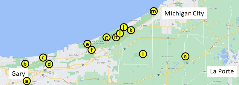
WEST BEACH TRAILS IN INDIANA DUNES NATIONAL PARK
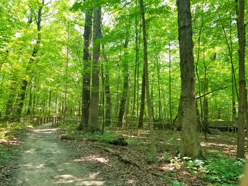
* find the map and more in our free travel guide *West Beach has three loop trails that you can combine into one 3.4 mile hike. Each loop trail leads you though a different eco system and if you combine them all into one hike as shown in the map below, then you will get an excellent overview of the Indiana Dunes flora, fauna and topography.
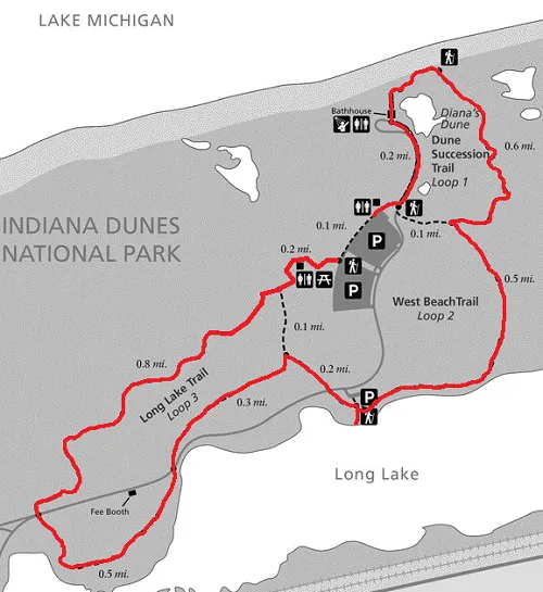
Start at the western end between the two parking lots at the wheelchair accessible path to the picnic coves and then continue on the sandy path and hike up the sand dune (Loop 3).

The hike up is the most strenuous part of this 3.4 mile hike and you will have a good view from the top.
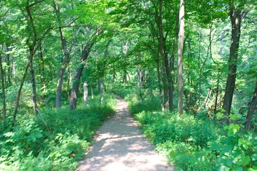
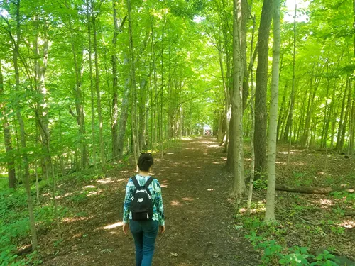
Continue on the well-marked trail through the forest and, if you come in July and August, notice the blackberry bushes. If they are not ripe yet, don’t worry. There are lots more in full sunlight which will be weeks ahead in their ripening cycle.
After almost half of the Loop 3 trail, you will come to the park entrance road. Cross the road and follow the sign to the right.
Unfortunately there is no sign that tells you to go through the first opening to your left and cross the second road. But that is exactly what you need to do. Cross the other road and follow the Long lake Trail back into the forest.
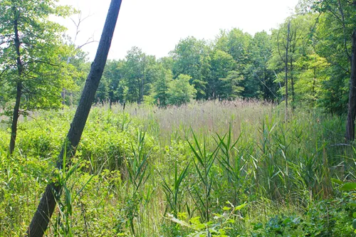
Fairly soon the path will exit the forest and you will get your first glimpse of Long Lake with the railroad tracks behind it – chances are that you will see and hear freight and passenger trains here. Depending on the time of year, there may not be too much water in this part of the lake.

Keep walking and a few feet before the trail crosses the road again is a viewing platform from which you can see a deeper part of the lake with more water. This is the second best viewpoint. The best viewpoint will come later.
Now cross the road and look at the ground – you should see small cacti on the ground. Many were blooming when we were there.
After 0.3 miles (0.5km), you will come to a sign that tells you that you can go left to the parking lot and right to the West Beach Trail (Loop 2). Go right and, soon after, you will cross the road again. Shortly after you crossed the road, you will see lots of blackberry bushes on either side of the trail. When we were there in early July, many bushes had fully grown super delicious blackberries. My wife picked so many that I was afraid we would never complete the trail.

After a few feet, there is a short walk to the right that brings you to the best viewing platform of Long Lake. If you are patient and quiet, you should see several bird species in this area.
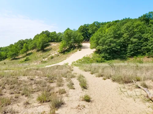
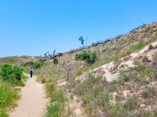
Go back to the trail and continue to the right. Soon, the trail will change into a sandy trail and tall forested sand dunes will appear.
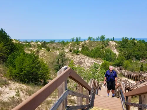
When you get to the wooden stairwell that goes up the dune to the right, take it and you are now on the Dune Succession Trail (Loop 1).
A lot of hiking on this trail is on a wooden boardwalk to protect the fragile landscape. There are multiple boards with information about “Diana of the Dunes” which I found very interesting.
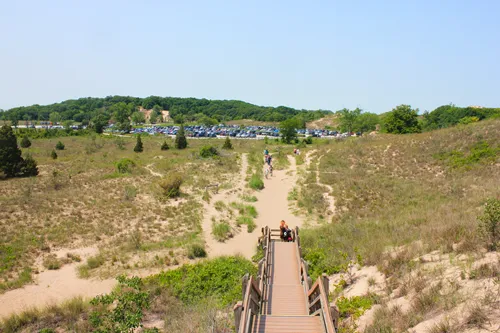

The trail will eventually bring you to West Beach. Where you can relax a little and enjoy beautiful Lake Michigan.
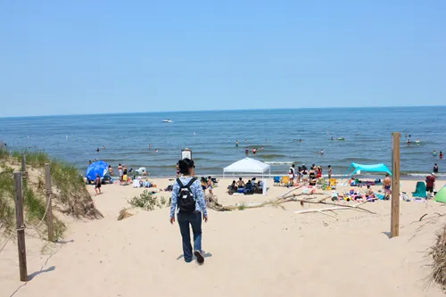
When you are ready to go back to the parking lot, go left along the beach for a few feet until you see the concrete stairs going up the concrete platform that brings you to the beach building with restrooms and a concession stand. From there, it is an easy walk back to the parking lot.
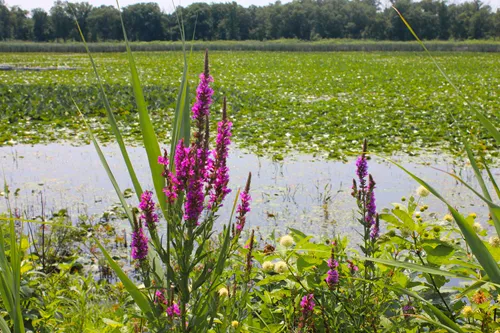
The West beach trails have lots of colorful flowers. Here are photos of some of them:


Back to Hiking Trails Overview
BAILLY AND CHELLBERG TRAIL IN INDIANA DUNES NATIONAL PARK
* find the map and more in our free travel guide *This trail has multiple parking lots from which you can start. The description below starts at, what the park map calls, “Volunteer Office & Comfort Station”. This is a good starting point as there are restrooms and picnic shelters.
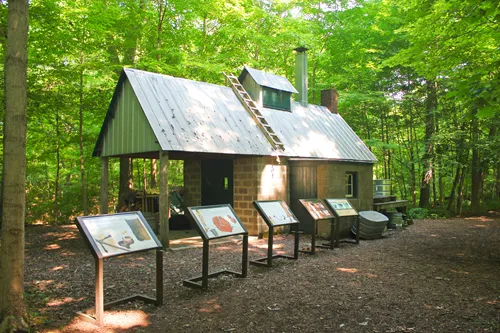
From the parking lot, enter the trail in the forest and turn right. After a few feet, you will come to a maple juice factory that dates back to the 1930s.
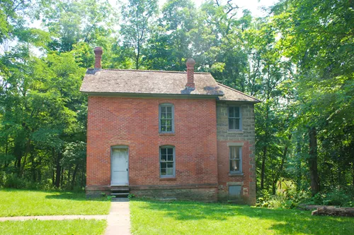
In the 1870s, Swedish immigrants Anders and Johanna Kjellberg bought 80 acres of land and built the farm that you will see in a few minutes. The name was Americanized and the Chellberg family lived here for three generations. The Chellbergs started maple syrup production here in the 1930s.
On the first two weekends in March, the annual Maple Sugar Time event is held here in which park rangers and volunteers demonstrate American Indian methods of boiling sap in open iron kettles and modern syrup production methods.
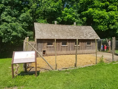
Now continue on to the Chellberg Farm which will come up on your right after about 1min. Go and visit the animals and buildings which are unlocked. There is also a Port-A-Potty - just in case.


Now, go back to the trail and after about ¼ mile, the trail splits.
The trail to the right is 0.3 miles long and leads to the Bailly Cemetery – after visiting the cemetery, you will come back the same trail to where you are standing right now.
If you go left, you will continue the on loop trail.
After another 0.1 mile on the loop trail, you will need to make another decision: continue left on the Bailly Chellberg trail or enter the Little Calumet River trail to the right and add 2.2 miles to your hike.

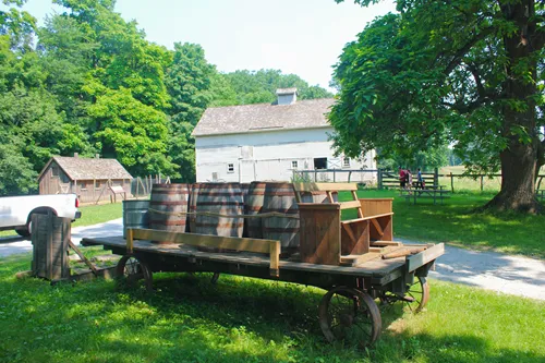
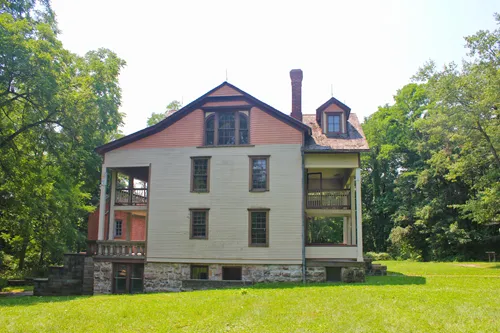
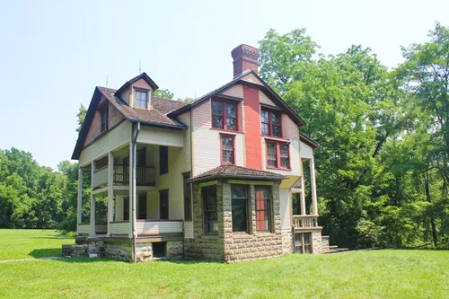
Either way, you will come to the Bailly Homestead which became a National Historic Landmark in 1962.
The buildings you see here are the homestead of Honore Gratien Joseph Bailly de Messein (1774 - 1835), who was one of the earliest settlers in this area. Bailly built his fur trading post in 1822 where the Little Calumet River met several trails of the local Native Americans. The site has several interpretive signs that tell the history of Billy and his trading post.

A short 0.3 mile hike through the forest will then bring you back to the parking lot.
Back to Hiking Trails Overview
CALUMET DUNES TRAIL IN INDIANA DUNES NATIONAL PARK
* find the map and more in our free travel guide *This easy 0.5 mile (800m) trail on the ridge of the Calumet Dune formed the shoreline of Lake Michigan about 12,000 years ago. Today, Lake Michigan is at 620ft (189m) above sea level.
The parking lot is at the old visitor center which is now the USGS Lake Michigan Ecological Research Station. Potable water is available at the parking lot.
Calumet Dunes Trail intersects with Glenwood Dunes Trail and Dunewood Trace Campground Trail.
Back to Hiking Trails Overview
COWLES BOG TRAIL IN INDIANA DUNES NATIONAL PARK
* find the map and more in our free travel guide *Named after Dr. Henry Chandler Cowles, an American botanist and ecological pioneer who did much of his early research in plant ecology and succession here, Cowles Bog has extremely high plant diversity and was designated a National Natural Landmark in 1965.
Cowles Bog Trail is a 4.7 mile (7.6km) moderate to difficult trail through savanna, swamp, marsh land and it also leads along the beach for 0.2 miles (300m). Climbing up some of the steep sand dunes can be difficult and tiring. Plan to rest at the beach and maybe picnic there before you head back to the parking lot.
Back to Hiking Trails Overview
DUNE RIDGE TRAIL IN INDIANA DUNES NATIONAL PARK
* find the map and more in our free travel guide *This 0.7 mile (1.1km) moderately difficult trail explores the wetlands and forests of a tall dune which borders on Kemil Beach to the north. As such, it shares a parking lot with Kemil Beach and that means that you must come early on summer weekends, because the parking lot will be packed otherwise.
Dune Ridge Trail may be short, but it showcases how diverse plant life is Indiana Dunes National Park.
Back to Hiking Trails Overview

GLENWOOD DUNES TRAIL IN INDIANA DUNES NATIONAL PARK
* find the map and more in our free travel guide *The ridge of the Glenwood Dunes is at 640ft (195m) above sea level and was once the shoreline of Lake Michigan before it receded.
The trail can either be accessed from the main parking lot of from Calumet Dunes Trail or the Dunewood Trace Campground Trail.
Glenwood Dunes Trail is a 6.8 mile (11km) easy to moderately difficult trail which frequently splits into parallel paths but does not necessarily combine in the same spot later on. So bring a map that you don’t get confused. Part of this trail is shared with horseback riders and cross-country skiers in winter.
Should the 6.8 mile trail be too short for you, then you can add the 2.6 mile (4.2km) Glenwood Dunes Extension trail and the 4.4 mile (7.1km) Dunewood Trace Campground Trail.
Potable water is available at the Glenwood Dunes parking lot and the Calumet Dunes parking lot.
Back to Hiking Trails Overview
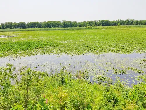
GREAT MARSH TRAIL IN INDIANA DUNES NATIONAL PARK
* find the map and more in our free travel guide *As the name suggests, this flat 1.3 mile trail goes through the Great Marsh, which happens to be the largest interdunal wetland in the Lake Michigan watershed. The wetlands are an important habitat and breeding ground for local birds and an important habitat for migratory birds. This easy and popular trail has an overlook of the marsh from where you should be able to see various birds such as Great Blue Herons and Sandhill Cranes.
Back to Hiking Trails Overview
HERON ROOKERY TRAIL IN INDIANA DUNES NATIONAL PARK
* find the map and more in our free travel guide *Unlike many other trails in Indiana Dunes National Park, Heron Rookery Trail is an A-to-B trail and not a round trip. It is 3.3 miles (5.3km) back and forth and the main parking lot (“parking lot 1”) is in the east.
The trail makes for easy walking as it follows the Little Calumet River for the most part. It gets its name from the large amount of Great Blue Heron nests that were found here in the past. The herons have moved on to new nesting grounds and nowadays you will find lots of other birds, like kingfishers, woodpeckers, etc.
This trail is particularly popular from late April to mid-May as it has the most beautiful display of wildflowers in Indiana Dunes National Park.
Back to Hiking Trails Overview
HOBART PRAIRIE GROVE TRAIL IN INDIANA DUNES NATIONAL PARK
* find the map and more in our free travel guide *From the parking lot you need to walk for 0.5 miles (750m) east on the Oak Savannah Trail to reach the trail entrance. The 2.2 mile round trip easy trail leads south to Lake George through bur oak savanna.
Hobart Prairie Grove is a late addition to the park (only added in 1992) and it preserves an area of 300 acres with an impressive 343 native plant species which gives refuge to lots of wildlife. This large biodiversity is made possible by a silt and clay soil that contains up to 30% sand.
Back to Hiking Trails Overview
INDIANA DUNES STATE PARK TRAILS
* find the map and more in our free travel guide *Indiana Dunes State Park has 7 hiking trails are accessed from various places within the park. Please refer to the trail map.
Trail 2
3 miles – Easy
The best trail for early spring flowers and ferns. Climax forest is used for cross-country skiing during the winter season.Trail 3
0.75 miles – Moderate
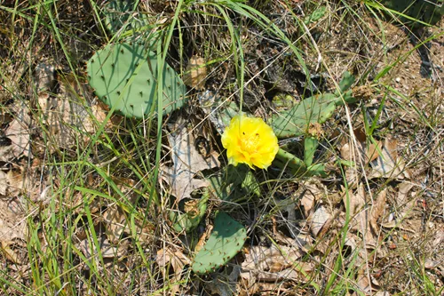
Provides an opportunity to view succession in dunes area. Excellent for late-spring wildflowers, including prickly pear cactus.Trail 4
0.75 miles – Moderate
Goes through dunes covered with black oak forest.Trail 7
1.1 miles – Moderate
Similar to Trail 4. Most direct route from Nature Center to beach.Trail 8
1.5 miles – Rugged
Goes over the tops of the three highest dunes of the Indiana Dunes.Trail 9
3.75 miles – Rugged
Provides best representative view of the dunes. Good view of lake.Trail 10
5.5 miles – Moderate
Hikers are rewarded by stands of white pine and a "tree graveyard" in Big Blowout. A good morning hike.
Back to Hiking Trails Overview
MOUNT BALDY SUMMIT TRAIL IN INDIANA DUNES NATIONAL PARK
* find the map and more in our free travel guide *Mount Baldy is 126ft (38m) tall, which makes it the largest “living” dune in Indiana Dunes National Park. It moves about four feet (1.20m) south every year and buries everything in its path. Parts of the dune are unstable and have swallowed up people in the past. Therefore, access to the dune is only permitted on ranger-led guided tours. The beach is open all year and accessible to anyone.
It is speculated that Mount baldy became a “living dune” only after uncontrolled access of people to the dune has mostly destroyed the marram grass that covered and thus stabilized the dune. The National Park Service has re-planted grass hoping to slow it down.
There are regular ranger-led daytime and sunset hikes on summer weekends and irregularly scheduled tours during the rest of the year.
You can find tours using the link above and by typing “baldy” into the “By Keyword” search field.
Back to Hiking Trails Overview
PAUL H. DOUGLAS TRAIL (MILLER WOODS) TRAIL IN INDIANA DUNES NATIONAL PARK
* find the map and more in our free travel guide *This trail is 1.7 miles one way. For anyone who does not want to hike this far, there are shorter walks at the Paul H. Douglas Visitor Center.
For the most part, this sandy trail is flat and the maximum elevation gain is 46ft (14m). As there are very few visitors on this trail, you have a chance of seeing wildlife, including beavers.
The first 2/3 of the trail goes through savanna with small ponds, wildflowers and oak tree covered dunes.
After the bridge which crosses the Grand Calumet River, the landscape changes and the trail winds through tall sand dunes until you reach Miller Woods Beach at the shore of Lake Michigan.
Back to Hiking Trails Overview
PINHOOK BOG TRAILS IN INDIANA DUNES NATIONAL PARK
* find the map and more in our free travel guide *Starting at the end of the parking lot is the 2.1 mile (3.4km) easy to moderately difficult Upland Trail. It goes through a forest that grows on a glacial moraine from 15,000 years ago. In a lower lying part is a bog which is not connected to ground water and, over time, has become fairly acidic and thus only acid tolerant plants can flourish here.
Starting at the right hand side of the parking lot starts the 0.9 mile (1.4km) Pinhook Bog Trail which can only be accessed on a guided tour with a ranger. Find out when guided tours leave on the park calendar and type “pinhook” in the “By Keyword” field. Be advised that you will walk on a floating boardwalk that submerges you walk on it for part of the Pinhook Bog Trail. So, be sure to bring waterproof boots.
Back to Hiking Trails Overview
TOLLESTON DUNES TRAIL IN INDIANA DUNES NATIONAL PARK
* find the map and more in our free travel guide *The Tolleston Dunes are the 2nd youngest of the four dune systems found in Indiana Dunes National Park. They were formed approx. 4,700 years ago as the shoreline of Lake Michigan at a time when the water level of Lake Michigan was at 605ft (184m) above sea level – today Lake Michigan is at 580ft (177m) above sea level.
The trail that can be accessed only from “parking lot 1” is 2.9 miles (4.7km) long and of moderate difficulty through dunes and marsh land.
The Tolleston Dunes Marsh Overlook can only be accessed through a 0.1mile (150m) boardwalk from “parking lot 2”.
Back to Hiking Trails Overview
Which part of Indiana Dunes National Park do you want to visit next?


Author: Rudy at Backpack and Snorkel
Bio: Owner of Backpack and Snorkel Travel Guides. We create in-depth guides to help you plan unforgettable vacations around the world.

Other popular Purple Travel Guides you may be interested in:
Like this Backpack and Snorkel Purple Travel Guide? Pin these for later: